"A comprehensive 3D spatial platform" that enables 3D measurement, analysis, and virtual placement in one place
3Dmapspocket®
What is 3Dmapspocket?
3Dmapspocket is a "comprehensive 3D spatial platform" that integrates point cloud data provided by the Dynamic Map Platform with Google Photorealistic 3D Tiles, enabling complex spatial verification such as measurement, analysis, and placement of highly accurate 3D environments directly in a web browser.
No software installation is required. Users can perform highly detailed situation analysis and recreate real-world environments directly on their own PCs.
Login
Enter your User ID and password to log in to the system
2D Map
Data registration area is displayed on a 2D map. Click anywhere you want to see 3D data
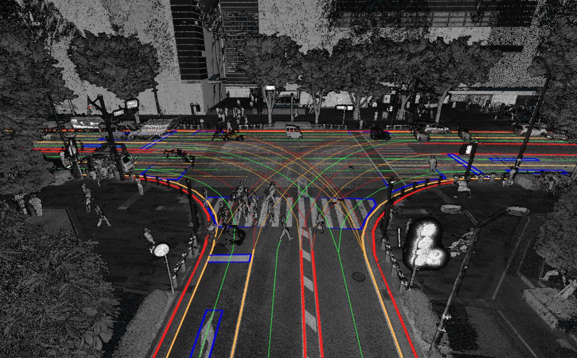
3D Map
Displays point cloud data/3D Tiles
Main Applications
Utilization of point cloud data
Highly accurate environment reproduction using point cloud data
By utilizing point cloud data, sites can be reproduced in highly accurate 3D.
Measurements such as distance and slope, verification of the number of road signs, verification of tunnel clearance widths, etc., can all be carried out directly from a desktop.
This helps optimize pre-site confirmation and measurement tasks conducted during report preparation.
Usage cases
CASE01
Challenges in traffic accident site surveys
Difficult to stop vehicles and conduct detailed on-site verifications on expressways and arterial roads
Conducting surveys during low-traffic hours (late at night or early in the morning) places a heavy burden on surveyors
Chronic shortage of surveyors
Expected Effects
Improving operational efficiency
By conducting measurements and preliminary studies in advance on 3Dmapspocket®, on-site visits can be minimized, enabling more efficient use of manpower and resources
Also reduces the man-hours required for creating as-built drawings and reports after surveys, contributing to overall workflow efficiency
Improving operational accuracy
Even for locations where detailed on-site inspections are difficult, such as expressways, distances and gradients can be accurately understood in 3D
Users can discuss while sharing visualized data, facilitating smoother communication and decision-making among stakeholders
Improving the working condition and safety of surveyors
Reduces the workload of surveys on major roads that previously required work during restrictive times such as late-night or early-morning hours, thereby easing workload and improving safety
Use case examples
CASE02
Challenges in road maintenance
Obtaining information about adjacent infrastructure or sections managed by other organizations requires significant time and cost
Ensures safety during on-site inspection
When pre-disaster data are not available, assessing damage during a disaster takes considerable time
Expected Effects
Improving on-site inspection efficiency
By using 3Dmapspocket®, users can check information such as adjacent infrastructure managed by other organizations, the number of road signs, tunnel clearance widths, etc., thereby improving the efficiency of site verification.
Improving field worker safety
By using 3Dmapspocket®, on-site work time can be reduced, helping improve the working conditions and safety of field workers.
Use case examples
Coverage
Covers expressways and major public roads in Japan.
Coverage of general roads will continue to expand through a partnership with NTT-ME
Situation reproduction based on the 3D environments of actual photos
Realistic, real-world urban environments can be reproduced using Google Photorealistic 3D Tiles.
By placing vehicle models and switching perspectives (driver’s view / bird’s-eye view / third-person view), accident scenarios and development plans can be visualized in three dimensions.
This makes it easier to explain scenarios to third parties and facilitates smoother discussions among stakeholders.
Usage cases
CASE01
Challenges in traffic accident site survey
Difficult to accurately share accident situations using only photos, drawings, and text
Misalignment in understanding distances and spatial relationships can occur, leading to delays in explanation and decision-making
Expected Effects
By placing vehicle models within 3Dmapspocket® and recreating accident scenes in 3D, distances and spatial relationships can be understood intuitively
Accident situations can be visually shared, smoothly aligning stakeholders' understanding
Compared to 2D drawings, the burden of explanation can be reduced and consensus-building can be streamlined
CASE02
Challenges in urban development sites
Building a 3D environment of surrounding areas takes time and money.
Revising camera angles in exterior 3D renderings requested by clients takes time.
Difficult to communicate views from buildings
Expected Effects
Enables easy construction of 3D environments, including their surroundings
Allows easy adjustment of 3D perspective angles
Makes it possible to convey realistic views and spatial impressions intuitively in a real 3D environment