



Dynamic Map Platform, a leading provider of High- Precision 3D Data for advanced driver-assistance systems (ADAS) and autonomous vehicles, today announced it has joined the Esri Partner Network (EPN) as a map and data provider. The partnership expands access to our precision mapping datasets across Esri’s ArcGIS ecosystem, making available high-precision geospatial data derived from Dynamic Map Platform’s approximately 975,000 miles of mapping coverage across the United States and Canada.

As a member of the Esri Partner Network, Dynamic Map Platform will publish High- Precision 3D Map Data and infrastructure asset data to global customers using Esri’s ArcGIS, including state departments of transportation (DOTs), municipalities, and private-sector companies seeking authoritative, survey-grade geospatial data for planning, asset management, and safety applications. Dynamic Map Platform brings automotive-grade geospatial certainty to the Esri Partner Network, extending the precision and reliability standards of ADAS and autonomous vehicle mapping to Esri’s ArcGIS customer base.
About the Partnership
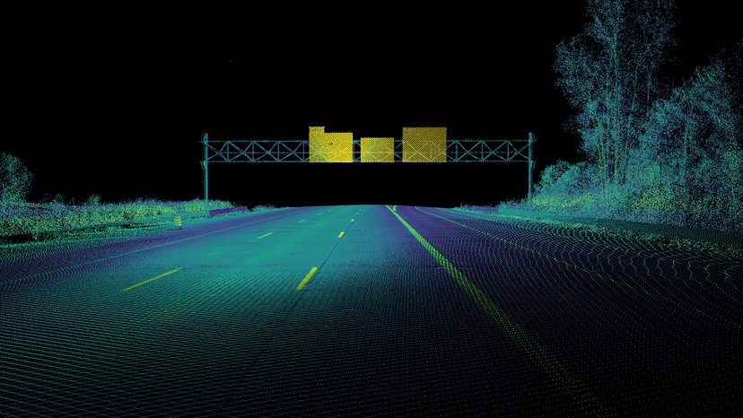
Dynamic Map Platform will provide high-precision geospatial datasets derived from approximately 975,000 miles of mapped roadway coverage across the United States and Canada through the ArcGIS ecosystem. These datasets include High- Precision 3D Map Data, LiDAR point clouds, roadway infrastructure assets, vertical clearance measurements, pavement markings, signage, and other transportation-related attributes. These datasets will be available through ArcGIS Marketplace, ArcGIS Living Atlas, and ArcGIS Dashboards, providing customers with data application-specific ArcGIS solutions. This will enable transportation agencies, municipalities, infrastructure operators, and private-sector organizations to incorporate Dynamic Map Platform’s high-precision geospatial data into their existing GIS workflows for visualization, analysis, and decision-making.
From this vast repository of “ground truth” data, Dynamic Map Platform extracts customer specific features such as road edges, lane dividers, crossings, and assets, and then supplement these observable features with virtual features like turn trajectories, virtual road edges, and light-to-lane assignments. Precision ground truth data and custom feature extraction enable transportation agencies and enterprises to incorporate Dynamic Map Platform’s precision data directly into their existing GIS workflows.
The partnership builds on Dynamic Map Platform’s growing footprint in transportation infrastructure mapping, including its work supporting state DOTs and automotive OEMs with high-accuracy mobile mapping and asset data collection. Joining the Esri Partner Network positions Dynamic Map Platform alongside a broader ecosystem of technology, data, and services providers built on the ArcGIS platform.
Dynamic Map Platform’s Esri Partner Network profile features three core solutions: Precision LiDAR & Imagery Data, High- Precision 3D Map Data, and Precision Clearance Measurement for bridges, tunnels, and other roadway features. More information on Dynamic Map Platform’s partnership and solutions is available at Dynamic Map Platform’s Esri Partner Network profile.
Dynamic Map Platform executives participated in the Esri User Conference in San Diego, California, July 13–16, where they engaged with leading geospatial companies from around the world.
About the Esri Partner Network
The Esri Partner Network (EPN) is a worldwide ecosystem of organizations that build and deliver software, services, and content using Esri’s ArcGIS platform. The network provides member businesses with specialized licensing, technical support, and go-to-market resources to integrate location intelligence into their own products and services. More than 2,800 global companies are part of the Esri Partner Network, spread across various tiers.
