Dynamic Map Platform Co., Ltd. (Head Office: Shibuya-ku, Tokyo; CEO & President: Shuichi Yoshimura; “Dynamic Map Platform”) announces its selection for the Ministry of Economy, Trade and Industry’s (METI) grant program, FY2024 Grant for Projects that promote International Rule Formation/Market Creation Standardization.
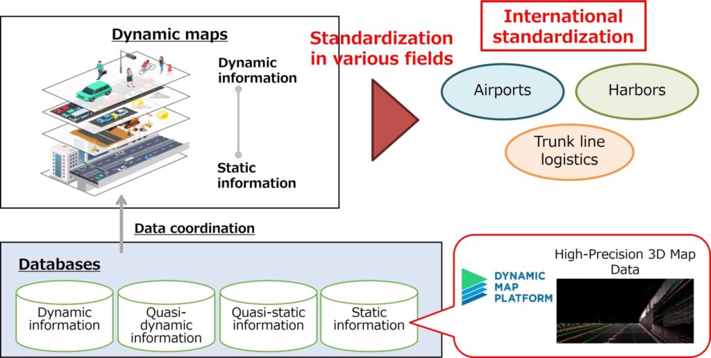
One of the themes of the open call for this grant program was projects that promote and support market creation to solve social issues through rule formation. Dynamic Map Platform was selected as an eligible grant recipient for proposing the High-Precision 3D Map Data International Standardization Project aimed at realizing an autonomous driving society by seamlessly connecting public roads and areas. This project is aimed at the international standardization of dynamic maps that are based on High-Precision 3D Map Data, taking into consideration the activities of the projects developed in collaboration with government agencies: BRIDGE, SIP, GI, and the International Standardization Acceleration Support Project*. Through this project, Dynamic Map Platform will make proposals to various industry associations related to the formation of global rules for public areas where the utilization of dynamic maps is anticipated, such as airports and harbors.
*
BRIDGE: Abbreviation for “programs for Bridging the gap between R&D and the IDeal society (society 5.0) and Generating Economic and social value”
SIP: Abbreviation for “Cross-ministerial Strategic Innovation Promotion Program”
GI: Abbreviation for “Green Innovation Fund Project: Smart Mobility Society Construction”
International Standardization Acceleration Support Project: A project that supports the acceleration of using standards in BRIDGE programs (International standardization of High-Precision 3D Map Data)
With the spread of autonomous driving, the fact that there are no international rules formed for the specifications of dynamic maps in public areas is one of the issues. Internationally standardizing dynamic maps through this project lowers the barriers to implementing autonomous driving in public areas and is expected to expand its global market. In addition, the standardized data can be widely used in public transportation, logistics, and disaster prevention, among other applications, providing more convenience to the entire society.