Driving demonstration of an autonomous driving truck as part of the “Digital Infrastructure Development Project for Digital Transformation of Industries/R&D for Infrastructure for Advance Implementation of Digital Lifelines” project

Driving demonstration of an autonomous driving truck as part of the “Digital Infrastructure Development Project for Digital Transformation of Industries/R&D for Infrastructure for Advance Implementation of Digital Lifelines” project
Service developed
a data coordination system that supports autonomous driving
Demonstration period
Tuesday, February 25 to Thursday, February 27, 2025
Target area
Between the Surugawan-Numazu and the Hamamatsu Service Areas on the Shin-Tomei Expressway
Demonstration details
Make an optimal operation plan for joint transportation, help autonomous driving vehicles run safely, adapt the operation plan to changes in the driving environment, support emergency response

Together with BIPROGY Inc., NEXT Logistics Japan, Ltd., and Yamato Transport Co., Ltd., Dynamic Map Platform has developed a data coordination system that supports autonomous driving as part of its efforts for the "Digital Infrastructure Development Project for Digital Transformation of Industries/R&D for Infrastructure for Advance Implementation of Digital Lifelines" project, an open call by the New Energy and Industrial Technology Development Organization (NEDO).

This initiative is part of the Ministry of Economy, Trade and Industry’s Digital Lifeline Development Plan.
https://www.meti.go.jp/policy/mono_info_service/digital_architecture/lifeline_portal/index.html
※Japanese website

Overview of system
  • Autonomous driving support system that uses dynamic map information delivery (Dynamic Map Platform): Developed a data coordination system that makes it possible to provide vehicles with high-precision weather information and road condition data, such as traffic, according to the shape of the road.

  • A system that shares information on near-miss scenarios through simulation (BIPROGY): Built a simulation environment using near-miss data obtained from vehicles and external systems.

  • A system that helps optimize joint transportation made with autonomous driving trucks in mind
     (NEXT Logistics Japan and Yamato Transport): Developed a system that matches cargo with the available space in trucks by entering the data required for joint transportation, such as cargo information and space availability in trucks, and an API that connects consignors with logistics companies.

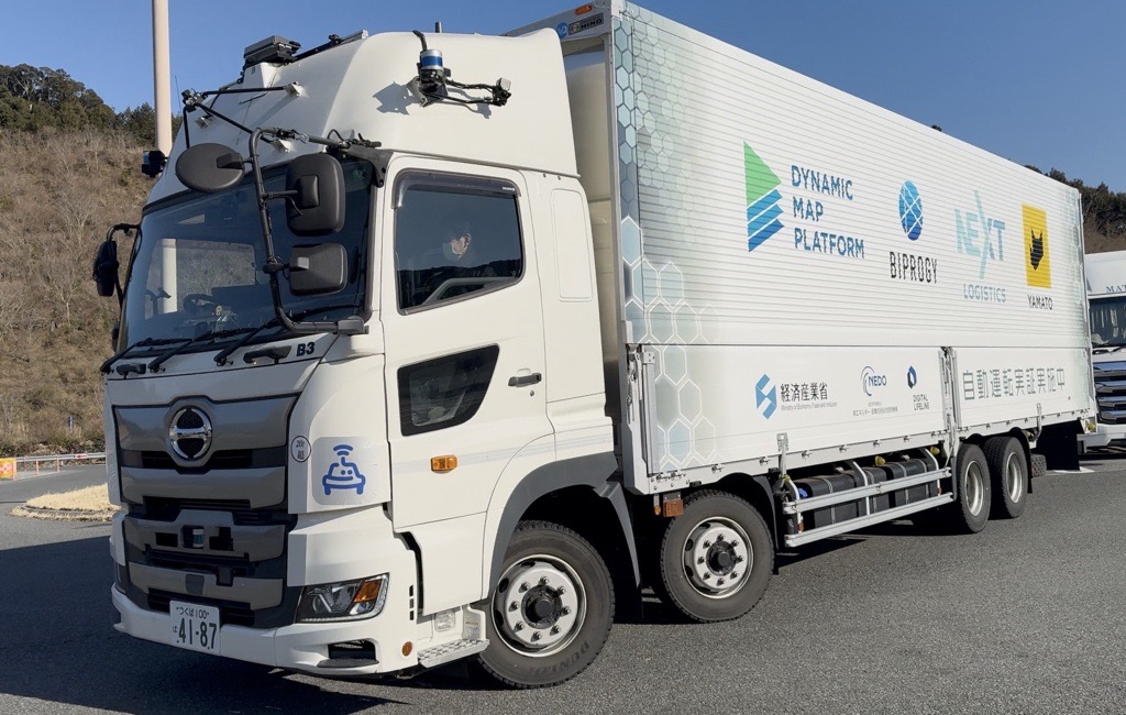
Development of a system that achieves safe and efficient logistics through autonomous driving and joint transportation

This system will contribute to optimizing logistics by helping autonomous driving trucks run safely and conduct joint transportation smoothly, thanks to coordination between the systems developed by each company involved in the project.

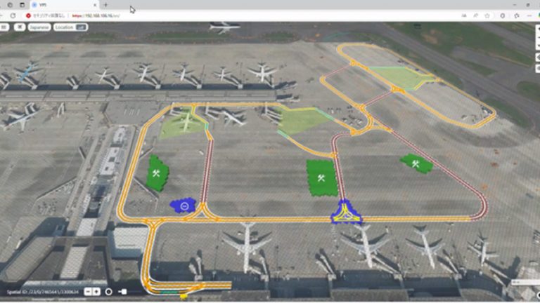
The (1) autonomous driving support system that uses dynamic map information delivery, developed by Dynamic Map Platform, allows a vehicle to recognize information that cannot be detected by the vehicle alone from several kilometers away. This system also provides logistics companies with accurate location information for vehicles, making it useful for operation management and in scenarios where decisions for withdrawing vehicles must be made during emergencies.

The (2) system that shares information on near-miss scenarios through simulation, developed by BIPROGY, makes it possible to provide diverse scenarios that help verify safety in the development phase of autonomous driving vehicles. The (3) system that helps optimize joint transportation made with autonomous driving trucks in mind, developed by NEXT Logistics Japan, Ltd. and Yamato Transport Co., Ltd, enables logistics companies to improve the loading efficiency and capacity utilization rate of their trucks.

On top of this, the companies created an environment that integrates (3), an autonomous driving remote monitoring system, and Dynamic Map Platform’s (1). They also implemented a traceability management design for joint transportation operations by developing a system that helps prevent unauthorized coupling of trailers and unauthorized pick-up by people impersonating consignors during joint transportation.

Expected outcomes

Provision of weather information and road conditions: Providing vehicles with environmental data obtained from external systems will allow the vehicle to recognize information from several kilometers ahead that the vehicle’s sensors would not be able to perceive, enabling safer autonomous driving.

Supporting logistics operations: Creating a framework that provides vehicle information and accurate vehicle positioning to nearby systems will ensure an understanding of the vehicle’s movements, enabling accurate operation management, decisions to withdraw vehicles, and instructions for this in an emergency.

It is anticipated that these functions will enhance loading efficiency through joint transportation, ensure high capacity thanks to the support for autonomous driving, and promote labor-saving in long-distance trunk transportation, said to account for 60% of logistics.

Click here
for related services

Location Information Services
Using "Spatial ID" for a wide range of applications.
Location Information Services

Click here
for a list of examples

Proposing plans that meet the needs of our clients’ projects